6
Looking up the creek bed, you will see that it bends sharply to the right about 100 ft uphill from the bridge. This is the spot, where the Hayward Fault meets the creek (star in figure 6.1). On the right (south) side of the creek bed is a Tibetan Retreat which is built on a hill. This hill is a shutter ridge, carried to this location by the movement of the Hayward Fault. The ridge prevented Hamilton Creek from flowing straight downhill. Instead the water was deflected to the northwest, following the trace of the Hayward Fault. At the bend, which you can see from the bridge, the Creek resumes its downhill flow. This is another example of an offset stream channel, like Strawberry Creek further to the northwest. But while the actual offset of Strawberry Creek is covered by the stadium, it is more obvious here at Hamilton Creek.
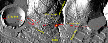
There seems to be some confusion about the name for this very short creek. On a topographic map dated approximately 1923 this Creek is called Hamilton Creek. Buwalda (1929) seems to be the first person to assign it the name Hamilton Gulch. He probably uses the word gulch because of the steepness of the creek’s upper reaches on the south slope of Panoramic Hill. Starting with the 1947 edition, however, the Oakland East map of the official 7.5 minute quadrangle topographic maps series assigns the name Hamilton Gulch to the upper headwaters of Strawberry Creek, above what is now the Botanical Garden. In their Creek & Watershed Map of Oakland & Berkeley Sowers and Richard (1993) make this creek one of the headwaters of Derby Creek. In his guide to the Hayward Fault Stoffer (2008) calls this creek Hamilton Creek. We are using the name Hamilton Creek and not Hamilton Gulch, in order not cause a mix-up with the Hamilton Gulch identified on the topo maps.
Trace your way back to the stone arch bridge. At the gate, turn left and continue on Hillside Avenue until you reach Dwight Way. Turn left and walk uphill to the intersection with Fernwald Road. The turn around and look down Dwight Way. This is stop 7 on figure 2, the last stop on our tour.
